This is your destination guide for United States.
This is your destination guide for Moab
📍 Part of United StatesFreestanding arches, slickrock under your tyres, and two national parks from one dusty desert town.
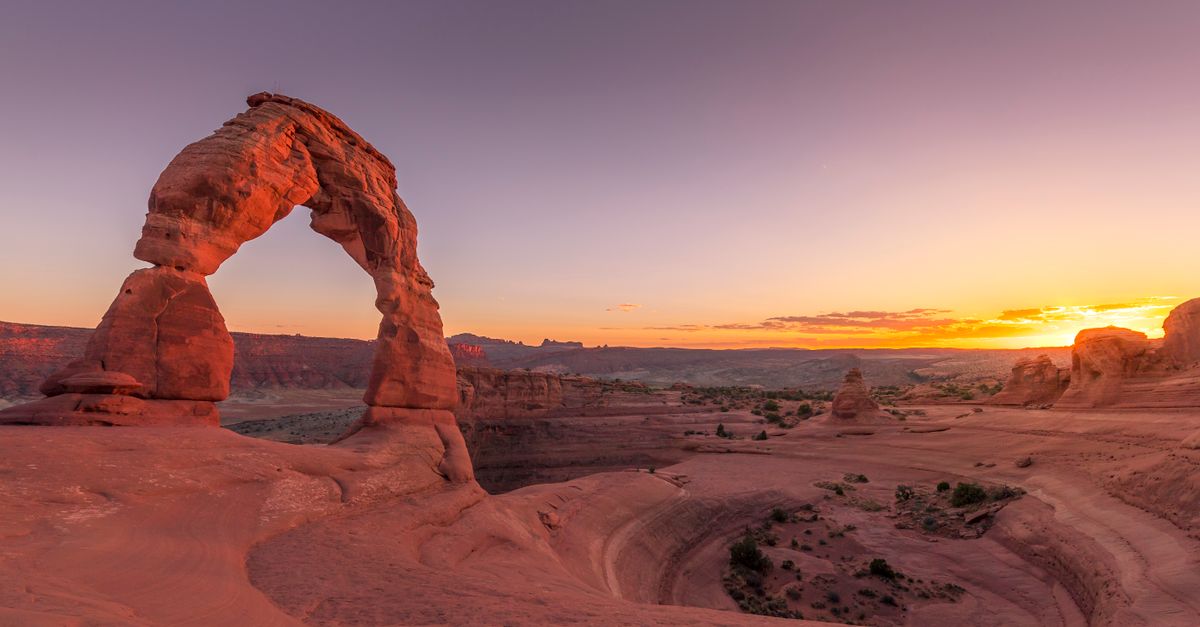

The reality: You leave Moab's one main street, drive five miles north, and the road runs straight into a wall of red sandstone fins. That's Arches. An hour later you could be standing on a cliff at Dead Horse Point as the Colorado River coils 600 metres below, or pointing a rented Jeep down a slab of bare rock on the edge of town. Moab is small — a few thousand people on one street — but it sits at the gate to two national parks and some of the best dirt in America.
It's an adventure base town, and it doesn't pretend to be anything else. No old quarter, no wine route, no spa-and-vortex scene. What there is: freestanding stone arches you can walk under, slickrock that grips a bike tyre like Velcro, 4x4 trails you drive yourself, and a brown, fast river running through the canyons. People come for one of those things and leave having tried three.
You'll want a car, more water than you think, and a tolerance for dust. Spring and autumn are the windows; summer is a furnace and the afternoon storms are real. Get up before the heat, point yourself at the rock, and Moab does the rest.
Moab's headline act is the rock itself: over 2,000 freestanding stone arches in one park, plus the spires, fins and balanced boulders around them.
Delicate Arch — the one on the Utah licence plate. A 3 km round-trip climbs open slickrock with no shade to a 16-metre arch standing alone on the rim of a natural bowl. Most people do it for sunset, which is exactly why the trail is a procession by 6 PM in spring. Go at sunrise and you might have it nearly to yourself.
Landscape Arch — at the end of the park road in the Devils Garden, a 92-metre ribbon of stone so thin it looks one tremor from falling (a slab did drop off it in 1991). Flat and easy, 30 minutes out.
Balanced Rock — a boulder the size of three buses perched on a thin pedestal, right beside the road. A five-minute loop.

The Windows — North Window, South Window and Double Arch sit a short walk from one car park, which makes them the easiest and the busiest. Worth it at dawn, a scrum by mid-morning.
Fiery Furnace — a maze of sandstone fins with no marked trail. You need a permit (10 USD self-guided, 16 USD ranger-led, booked on recreation.gov) and a willingness to get briefly lost. The one corner of Arches that still feels like exploration.
Corona Arch — outside the park on Potash Road, a 5 km round-trip to an arch as big as the famous ones, with no entrance gate and a fraction of the people.
Everything is a day trip from the one town. Here's how the map breaks down.

Moab itself — one long main street of gear shops, taco joints and bike racks, wrapped in red cliffs. Not pretty in a postcard way; it's a basecamp, and it works like one.
Arches National Park — five miles north, the formations above, strung along a 30 km scenic road.
Canyonlands — Island in the Sky — a flat mesa 40 minutes from town, ringed by cliffs that fall away into a vast, broken maze of canyons you mostly can't reach by road. Mesa Arch frames the sunrise (the rising sun lights the underside of the arch — get there early, it's no secret). Grand View Point looks out over a hundred miles of wilderness. This isn't the one famous mile-deep abyss everyone photographs — it's wider, emptier and harder to take in from a railing.

Canyonlands — the Needles — the park's southern half, 90 minutes south near Monticello. Sandstone spires banded red and white, long backcountry trails, almost no crowds. For walkers who want effort, not viewpoints.
Dead Horse Point — a state park on the way to Island in the Sky, where the Colorado swings in a tight loop 600 metres below a sheer cliff. The best sunset view near Moab, and you'll share it.
Castle Valley & Fisher Towers — up Highway 128 along the river, a valley of dark-red spires that climbers and film crews love. The rafting trips put in here.
Monticello — 50 miles south and a few hundred metres higher, so cooler in summer. A plain, quiet town that makes a good base for the Needles when Moab is booked out or too hot.
Where American adventure sports go to get serious.
This is not flow trails and gentle e-bike loops — it's technical slickrock, self-driven 4x4, exposed singletrack and big water. There are easy versions of all of it (the Bar M trails for bikes, the Daily for the river), but the place is built around the hard stuff.
The Colorado runs right past Moab, and it's the third reason people come — after the rock and the bikes.
The half-day Fisher Towers run (the "Moab Daily") is the gentle introduction: about 11 km of calm water and splashy Class I–III rapids below red spires, 80–110 USD, fine for kids. The water is biggest and fastest in May and June when the Rockies melt; by late summer it drops and warms enough to swim.
For more, Westwater Canyon steps up to Class III–IV in a black-walled gorge upstream. And Cataract Canyon — a multi-day trip through the bottom of Canyonlands — is the serious one, with rapids that rival the Grand Canyon's at peak flow. Book those well ahead.
Moab eats like the adventure town it is: big portions, early breakfasts, cold beer after the trail. Don't come for fine dining — come hungry after a long day.

The Moab Brewery is the institution — a barn of a brewpub on Main Street pouring its own beer to dusty bikers and rafters. Milt's Stop & Eat, a 1950s burger-and-shake counter near the Slickrock trailhead, is the other local fixture.
For dawn starts, the coffee roasters and breakfast-burrito places on Main open early on purpose — everyone here is trying to beat the heat.
There's no wine scene out here. Moab runs on beer, burritos and the kind of breakfast that gets you up a mountain before the sun does.
April–May — the prime window. Highs 16–28°C, wildflowers late April, the rock at its best. Busy on weekends, and March hotel prices spike with spring break.
September–October — the other sweet spot. Cooler, fewer people than spring, cottonwoods and the La Sal aspens turning gold by late October. Days shorten fast.
June–August — hot, often near 40°C, the slickrock too hot to sit on by noon. Monsoon season (mid-June to September) brings violent afternoon thunderstorms and genuine flash-flood danger in canyons and washes. Strenuous trails become a dawn-only proposition. The worst time for most people — but it's when families have the school holidays, so the town stays busy anyway.
November–February — quiet and cheap. Sunny but cold (7–15°C by day, below freezing at night), the odd snowfall dusting the red rock, which is a strange and empty kind of beautiful. Some high trails hold snow; the dark skies are unbeatable for stars.
You need a car. Moab is a base town with no public transport worth the name, and the arches, viewpoints and trailheads sit miles apart. Most people fly into Salt Lake City (3.5–4 hours' drive) or Grand Junction, Colorado (under 2 hours); tiny Canyonlands Field just outside town has a handful of flights.
A normal rental car reaches every paved viewpoint and trailhead — you only need a 4x4 for the backcountry routes, and most people rent those separately for the day.
One current catch: now that Arches has dropped its timed-entry reservation for 2026, the real limit is parking. Lots fill by mid-morning in spring and autumn, and rangers close them when they're full. Arrive before 8 AM or after 3 PM.
Pick a base for how you want your days to start. Moab is small, but each option has a different feel.
Downtown Moab — walk to beer, tacos and gear shops. Books out earliest; reserve months ahead for spring and autumn.
North Main / Highway 191 — a few minutes closer to Arches, more chain hotels with pools, easy parking.
The river corridor (Highway 128) — lodges strung along the Colorado under the cliffs. Scenic, pricier, calmer; a short drive from town.
Camping & glamping — Devils Garden inside Arches (reserve up to 6 months ahead), BLM riverside campgrounds along the 128 and 279, and glamping tents and cabins on the edge of town.
Monticello — 50 miles south, cheaper and cooler, good for the Needles or as overflow when Moab is full.
Moab is a mid-priced adventure town — no Jackson Hole, no Sedona spa resorts. A bed is reasonable most of the year, but rooms sell out and climb in spring and autumn; what really adds up is the gear, guides and shuttles.
Prices in 2026 US dollars. A Southeast Utah Parks pass ($55) covers both Arches and Canyonlands for a year and pays off on day two. Winter knocks 40–50% off lodging; July fills anyway, heat and all.
Go if you want red-rock adventure with your own hands on the wheel — two national parks, slickrock trails, self-drive 4x4, and the Colorado at the bottom of it all. Skip if you came for guided comfort, summer heat scares you, or you pictured the arches without the crowds.
Found this useful? Share it.
Still planning?
We don’t stop at “here’s the country.” Real places to stay, what to do, apps that matter, even how to find someone to travel with — plus guides for whatever vibe you’re after, from beach days to wine country to slow weekends. All up top. Spin for somewhere new when you’re done with this one.