
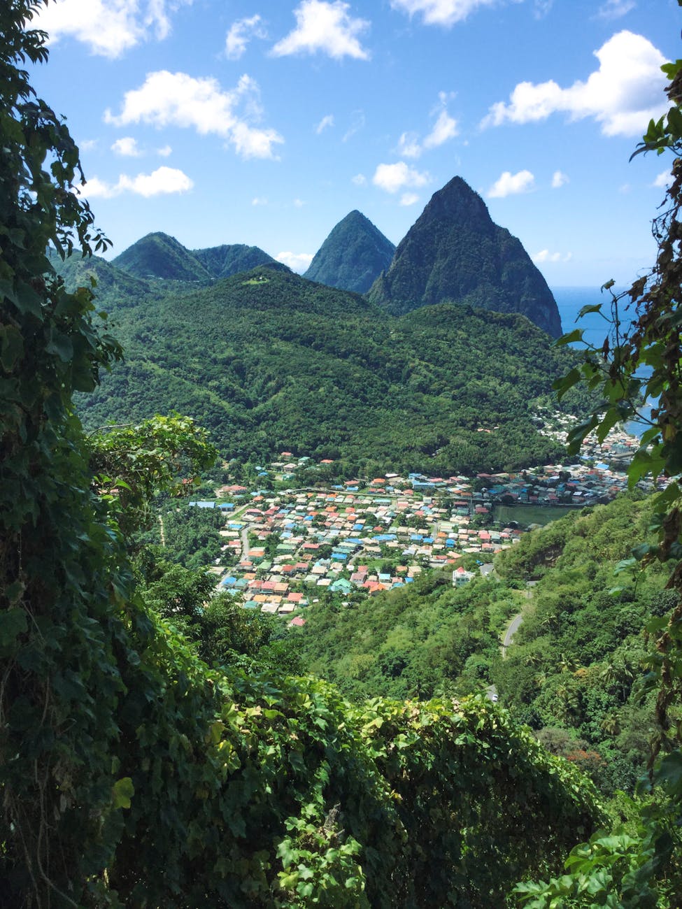
Soufrière is the oldest European settlement on the island, founded by the French in 1746, and it sits at the foot of both peaks on the sheltered southwest coast. The town itself is a working fishing port with a waterfront square and a weekend market, but everything surrounding it is extraordinary. This is the part of Saint Lucia that most visitors make the long road journey south to find.
Gros Piton rises 798 metres (2,619 feet) from sea level. A guided climb is the standard approach: the trail begins at Fond Gens Libres village south of Soufrière, gaining 550 metres through forest and scrub. A local guide is mandatory. The ascent takes 2.5–3 hours; the descent is faster. The summit view—both Pitons below you, the Caribbean to the west, Saint Vincent visible to the south on clear days—justifies every step. Petit Piton at 743 metres is technically harder and requires advance arrangement with the Pitons Management Authority.
Sulphur Springs sits 3 kilometres northeast of Soufrière—billed as the world’s only drive-in volcano, which is technically accurate: the road leads directly into the collapsed caldera. The site is active. Mud pools bubble, steam vents through the ground, and the sulphur smell arrives 500 metres before the entrance. The mud bath—where visitors coat themselves with grey volcanic mineral mud—is slightly ridiculous and entirely worth doing.
Diamond Falls Botanical Gardens occupies six acres of former estate land 2 kilometres from Soufrière. The waterfall at the centre flows over mineral-stained rock in colours that shift between gold, green, and violet depending on the light and the season. The mineral content comes directly from the Sulphur Springs system. The gardens also hold a small mineral bath that Empress Joséphine—born on Martinique and connected to Saint Lucia through the colonial era—is said to have used during visits to the island.
The Tet Paul Nature Trail begins on a working farm above Soufrière and follows a ridge above the Pitons Management Area. The walk takes under an hour at a relaxed pace. The payoff is a stairway cut into the hillside—locals call it the Stairway to Heaven—that ends at a platform looking directly between Gros Piton and Petit Piton out to the Caribbean. Arrive before 9am to have the viewpoint to yourself.
Castries was rebuilt multiple times after colonial-era fires, which means the city centre is largely 20th-century architecture rather than the preserved streetscapes found elsewhere in the Caribbean. What it does have is function: a deep-water cruise port, a working Central Market on Jeremie Street where vendors sell christophene, plantain, scotch bonnet peppers, fresh nutmeg, and madras fabric, and Derek Walcott Square at its centre—named for the Saint Lucian poet who won the Nobel Prize for Literature in 1992.
Morne Fortune rises above the city to the east. The hill—whose French name translates roughly as Hill of Good Fortune—holds old military fortifications that controlled the harbour through successive British and French occupations. The views from the top take in Castries, the harbour entrance, and the northern coast running toward Rodney Bay. La Toc Beach on the southern slopes is a quiet public beach rarely crowded with tourists.
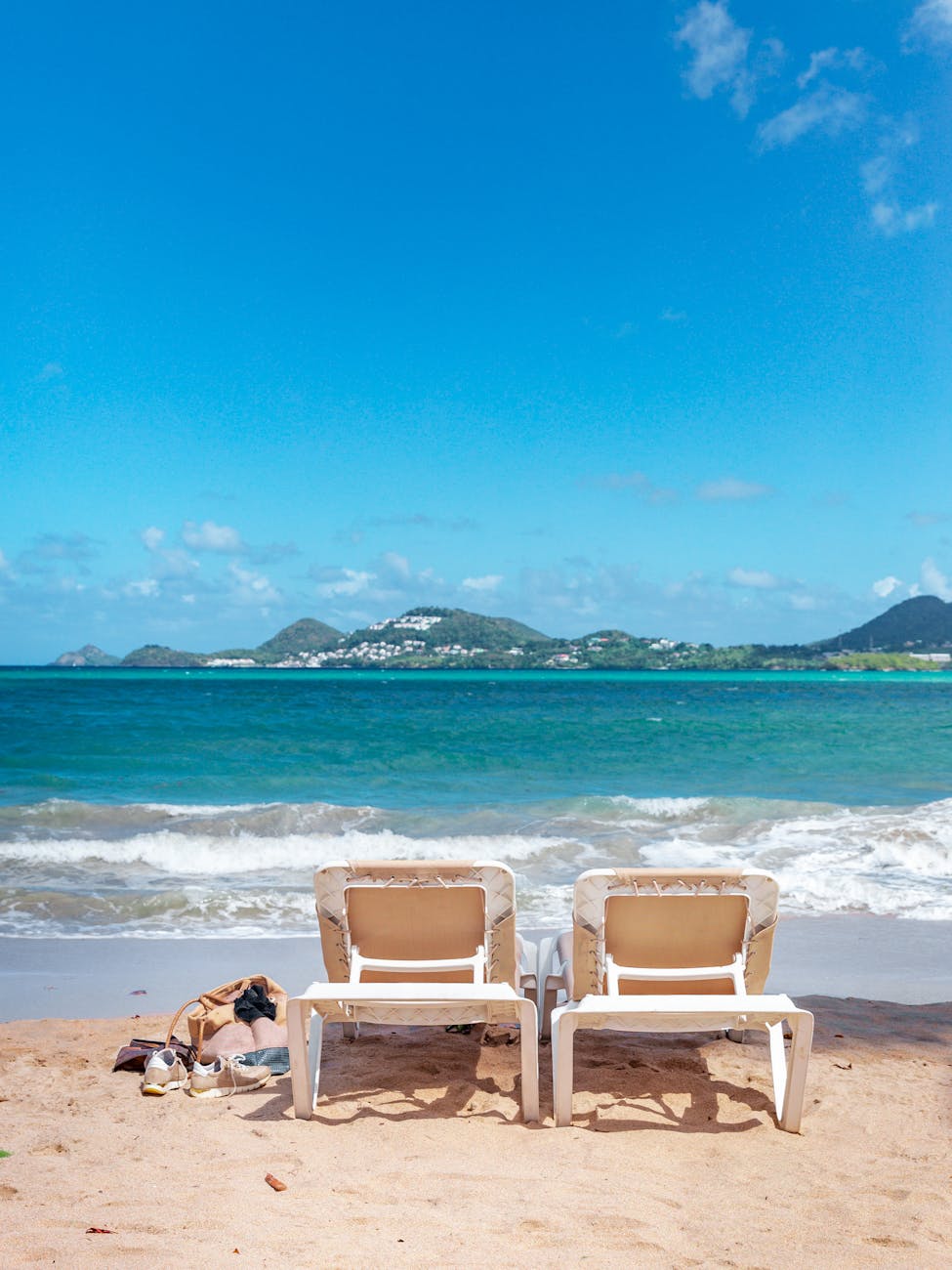
Rodney Bay, 8 kilometres north of Castries, is the island’s main resort and leisure zone. The marina holds over 230 berths and runs a December sailing festival that draws yachts from across the Atlantic. Reduit Beach fronts the bay—a long, calm, public beach with water sports rentals and vendors along the shore. The bars along the strip stay busy from mid-morning.
Gros Islet is a small fishing village 2 kilometres north of Rodney Bay that transforms every Friday night into the loudest square mile in the Eastern Caribbean. The weekly Jump Up has run for 50 years: streets close to traffic, speakers go up on every corner, vendors grill chicken and fish in open-air stalls, and cold Piton beers flow from roadside coolers. It’s entirely informal, completely free to attend, and considerably more entertaining than most things that cost money.
Pigeon Island National Park occupies a former islet connected to the mainland by a causeway north of Rodney Bay. The ruins of Fort Rodney—a British garrison that once controlled the channel between Saint Lucia and Martinique—spread across two hilltop summits. The view from the upper fort takes in Martinique on clear days. The park includes a small beach, a museum in the former officer’s quarters, and hosts the Saint Lucia Jazz & Arts Festival each May.
Saint Lucia’s interior is mountainous rainforest, cut through by rivers and plantation land. Rainforest Adventures operates an aerial tram through the canopy above Chassin, northeast of Castries—gondolas that travel slowly through the upper forest layer while a guide identifies plants and birds. The Saint Lucia Parrot—endemic to the island and protected since a conservation campaign in the 1970s reversed a sharp population decline—can occasionally be spotted in the mid-forest elevations. The tram trip takes 2–3 hours and suits all fitness levels.
Anse Chastanet, accessible by road or water taxi from Soufrière, is the reference point for diving and snorkelling on the island. The reef begins directly off the black-sand beach, within swimming distance of shore: coral walls, angelfish, trumpetfish, hawksbill turtles. The underwater zone sits within the Pitons Management Area, which protects 168 fish species and 60 types of coral. Dive operators run trips from the beach, and snorkelling tours are available for all levels.
Marigot Bay sits 9 kilometres south of Castries on the west coast—a sheltered natural harbour described by everyone who arrives by water as the most beautiful bay they have encountered in the Caribbean. The bay narrows to a channel between two palm-covered headlands; a small ferry crosses every few minutes. The bay fills with yachts throughout the winter sailing season and is largely quiet outside of it. It is one of those places that rewards the decision to stop.
Anse La Raye is a fishing village between Castries and Soufrière where the boat ramp leads directly to the Caribbean and the catch comes in fresh each morning. On Friday evenings the village runs its own street seafood market—smaller and quieter than Gros Islet—where grilled fish and seafood is served straight from the grill alongside local rum punch. It is 23 kilometres from Castries and worth the drive south.
The west coast road between Castries and Soufrière runs through the mountains and along cliff edges above the sea. It is narrow, winding, and scenic enough to demand that drivers slow down regardless of schedule. Allow 90 minutes for the 47-kilometre journey. The road is the journey as much as anything waiting at either end.